
Scenic Driving Tour
 The return of our feathered friends coupled with the bloom of spring flowers during the months of April, May and June provides theperfect opportunity to explore the Laurel Highlands. This day long driving tour will guide you to some of our area's best birding spots from a mountain top bog to the deepest gorge in Pennsylvania. This approximately 100 mile loop will take a minimum of 5 hours.
Directions to first stop
- Drive Route 711 North (Laurel Highlands Scenic Byway) for approximately 2 miles
- Turn left onto Donegal Lake Road and drive approximately 1 mile
- You will drive past the first parking lot on the right and turn right into the next parking lot (West Parking Lot)
Stop 1 - Donegal Lake
Formerly known as Fourmile Run Dam, Donegal Lake is a 90 acre impoundment located at the base of Chestnut Ridge. It is part of a 232 acre property owned and managed by the PA Fish and Boat Commission. The lake and emergent marsh along the water's edge provide habitat for waterfowl and other birds.
The variety of plants in and around the lake provides both food and nesting locations for waterfowl. Waterfowl feed on seeds, underground tubers, aquatic grasses and sedges, submerged pond weeds, crustaceans, clams, fish eggs and fish. The cattails, grasses and shrubs provide cover and protection for nests.
In North America, 75% of bird populations migrate between two habitats - a temperate breeding habitat and a tropical overwintering habitat. Birds migrate to tropical regions because winter is too harsh and food is plentiful further south. Birds migrate back to these breeding grounds to take advantage of abundant food supply in spring and summer. They also return because reproductive rates are better with larger clutches, more broods per season and less predation and parasites.
In Pennsylvania, waterfowl migration peaks in mid-March as these birds arrive in large flocks to open water and abundant food, some to remain here and others to migrate further north. Their colorful breeding plumage makes them easier to identify. Look for tundra swans, common loons and common mergansers.
Directions to next stop:
- Turn left out of parking lot to return to Route 711.
- Turn left onto Route 711 North
- Drive approximately 2.4 miles to Stahlstown and turn right onto Route 130 East
- Turn 3 miles and turn right onto Route 381South
- Drive 2.7 miles and turn right onto Hunters Lane (gravel road) - just before sign for Forbes State Forest.
- Cross concrete bridge over Indian Creek and pull off in small grassy area to the left near trail head (Blair Brothers Railroad Trail) - Do NOT block gate access.
Stop 2 - Forbes State Forest - Hunter's Lane
The early-stage brushy habitat here in the Hunters Lane Area is the largest area of this type on the 60,000 acre Forbes State Forest and is a magnet for various species of wildlife, especially birds. This area is easily accessible by hiking the flat 1¼ mile Blair Brothers Railroad Trail, starting from Hunters Lane near the bridge over Indian Creek.
In the early stages of forest succession, many small tree seedlings and saplings mix with shrubs and grasses to create thick dense undergrowth valued by wildlife like deer, bear, and many species of birds. They are attracted to the cover this habitat provides to conceal their nests, offspring, or themselves from predators or even humans like yourself.
Walk quietly along the trail, stopping to look and listen. Birds you might see include the indigo bunting, common yellowthroat, gray catbird, ruffed grouse, blue-winged warbler or American goldfinch. You may even catch a glimpse of a great-blue heron as it travels to and from Indian Creek.
Many birds also prefer and need this brushy habitat because of the abundance of food it provides, such as insects and caterpillars in the summer and soft berries in the fall and winter.
Directions to next stop:
- Return to Route 381
- Turn left onto Route 381 North and drive approximately 5 miles
- Turn left into parking area for Powdermill Nature Reserve
Stop 3 - Powdermill Nature Reserve
Established in 1956, Powdermill Nature Reserve covers nearly 2,200 acres and is a biological research station for the Carnegie Museum of Natural History. Their world renowned bird banding station, established in 1961, is one of the longest continually operating avian research stations in the United States.
Bird banders record physical characteristics of various bird species to monitor populations in the wild. Information gathered increases our understanding of bird behavior, migration and life spans and is used to determine habitat use and presence of environmental toxins.
The research on the Louisiana waterthrush done at Powdermill is used to determine the ecological health of the watershed. One of the earliest warblers to arrive in the spring, it is unique for its specific habitat requirements of forested, fast-flowing streams and a primary diet of aquatic macroinvertebrates. In addition, waterthrushes tend to return to the same stream each year often reusing the same nests.
This study is important for watershed management since these streams drain the majority of the watershed and influence downstream water quality. Watersheds with no or low populations of Louisiana waterthrushes may indicate poor water quality.
Explore the education center to learn more about birds and current research. To participate in one of the bird banding demonstrations given on the weekends, call 724-593-7521.
Directions to next stop:
- Turn left out of parking lot and continue on Route 381 North to Rector
- Turn right onto Linn Run Road and follow into Linn Run State Park
- Drive approximately 3.3 miles and turn right into the parking area for the Grove Run Trail Picnic Area
- Follow a portion of the trail for a short hike
Stop 4 - Linn Run State Park - Grove Run Trail
Linn Run State Park and adjacent Forbes State Forest recently celebrated its 100 year anniversary. Established in 1909, the Linn Run area has been a destination for hikers, fishermen and birders for more than a century.
The Grove Run Trail located near two popular natural artesian springs is a 4 mile trail climbing over 1,000 feet through mature forest. Sturdy shoes are recommended as you walk 100 yards to enter the forest interior to discover the birds that live there.
Many forest bird species need interior forests to survive. This deep, unbroken forest is a secluded environment with a closed canopy, dense understory and mature trees providing preferred food and nesting conditions. Warblers and vireos eat large quantities of forest insects including gypsy moth and tent caterpillars. Other forest birds thrive in this habitat with fewer predators and less disturbance for nesting. In fact, during the breeding season, 1 out of every 6 scarlet tanagers worldwide flocks to the forests of Pennsylvania!
Look for the wood thrush, red-eyed vireo, blackburnian warbler, pileated woodpecker, ovenbird and scarlet tanager. Each of these bird species has a unique song which fills the air while you journey along the trail.
 Directions to next stop:
- Pull out of the picnic area parking lot and turn right to continue on Linn Run Road up Laurel Mountain into Forbes State Forest. After approximately 4 miles, this road becomes a gravel road.
- Follow this road to Laurel Summit State Park and turn left into parking area
- From parking area, hike the ¼ mile long trail to Spruce Flats Bog
Stop 5 - Spruce Flats Bog
The 28 acre Spruce Flats Bog is part of the 300 acre Spruce Flats Wildlife Area of Forbes State Forest. Hike the ¼ mile Bog Trail from the parking area at Laurel Summit State Park to the boardwalk at the end of the trail that reaches out into the bog.
Past geologic activity left a depression on top of Laurel Ridge. This depression passed through natural succession from open water to swamp, to bog, to meadow and finally to forest. Lumbering of the forest caused the water table to rise while fires burned away the upper layers of organic matter. These events recreated the bog.
This upland bog is unique to the area. The limited nutrients, acidic soils and large amounts of organic matter support plants that are typically found further north including large cranberry, cotton grass and the insect-eating pitcher plant and sundew. Likewise, certain bird species not found in the surrounding hardwood forest prefer the marshy openings and evergreen trees of this bog area.
Keep alert and you might catch a glimpse or hear the call of a yellow-billed cuckoo, common raven, rose-breasted grosbeak, red tailed hawk, veery, hooded warbler or winter wren.
Spring Ephemerals
Late April and early May bring the bountiful blossoms that indicate winter's end. The cool moist climate of the forest provides a perfect landscape for the early flowers of this season, known as spring ephemerals. These flowers must grow quickly to take advantage of the abundant sunlight on the forest floor. In a few short weeks the tree leaves will completely shade the ground and they will rest for another year. Look for trilliums, skunk cabbage, may apples and coltsfoot as you drive to your next stop
Directions to next stop:
- Turn right out of parking area to return back on Linn Run Road
- Bear left onto Hickory Flats Road (gravel road) and drive 3.8 miles
- Turn left at stop sign onto Old Hickory Flat Road (gravel road) and drive a short distance.
- Turn right at "T" at stop sign onto Rocky Ridge Road
- Drive a short distance until you see turnpike on your right. Turn right at stop sign onto Bakersville-Edie Road, cross bridge over turnpike and bear to the right.
- Drive 3.4 miles to Bakersville. Turn left by church at stop sign at the "T"
- Drive to stop sign at intersection with Route 31
- Turn left onto Route 31 East
- Drive .3 miles and turn right onto Trent Road
- Drive 1.6 miles and turn right into Laurel Hill State Park.
- Follow park road for approximately 1 mile to bridge and parking area at the bottom of the hill.
Stop 6 - Laurel Hill State Park - Laurel Hill Creek Bridge
Laurel Hill State Park comprises nearly 4,000 acres and shares a border with Forbes State Forest. Wildflowers occur here both naturally and as a part of the garden plantings by staff and volunteers.
The large flower bed near the bridge is planted with wild columbine. This flower blooms from late April through early June. It attracts hummingbirds with its red and yellow flowers.
The flowering time for this plant is particularly important because it is in full bloom when the ruby-throated hummingbird is migrating back to this area from the Yucatan Peninsula of Mexico. This tiny bird is a nocturnal migrant that can reach flight speeds of 60 mph. The flower provides a much needed food source after the lengthy non-stop flight over the Gulf of Mexico and benefits from the pollination provided by the hummingbird. Look for the iridescent flash of color among the flowers as the ruby-throat feeds on nectar as well as small insects needed for protein.
Across the stream along the hillside above picnic area #4 is a large stand of naturally occurring Oswego tea, also known as scarlet bee-balm. This red flower also attracts hummingbirds and butterflies during its bloom in July and August.
- Continue to follow park road for approximately 2.2 miles to the park visitor center and turn right into parking area.
Stop 7 - Laurel Hill State Park - Visitor Center/Meadow
The meadow located across the road from the park visitor center provides an excellent chance to get up close to many beautiful native wildflowers.
Walking trails throughout the meadow lead you through beautiful native grasses and wildflowers that provide food for multiple species of birds. Daisies, coreopsis, and purple cone flower thrive in the meadow attracting finches, cardinals, sparrows and towhees when they produce seeds in the late summer and early fall.
This meadow surrounded by open woodlands is a perfect location for the Bluebird Trail - a trail of bluebird boxes that is part of a volunteer-run cavity nesting program hosted in most Pennsylvania state parks. The program was originally created to help increase the declining eastern bluebird population due to loss of habitat and the use of pesticides. Bluebirds are primarily insect eaters that forage for grasshoppers, crickets and other insects found here. Only partially migratory, the northern most bluebirds will fly to the southern United States for the winter and return here to nest for the breeding season.
The meadow and visitor center gardens are successful because of the dedication of volunteers. Stop in the Laurel Hill Visitor Center to learn more about the park and volunteer opportunities.
Mountain Laurel
The closer you get to Cranberry Lake, notice the distinctive pink and white flowers of mountain laurel commonly found on the rocky hilltops. On May 5, 1933, Governor Pinchot designated the mountain laurel as Pennsylvania's state flower. This evergreen shrub grows four to ten feet in height and is one of the few evergreen shrubs native to Pennsylvania. Here in the Laurel Highlands this shrub blooms late May through early June.
Directions to next stop:
- Turn right out of visitor center parking area and follow the park road to the intersection with County Line Road
- Turn left onto County Line Road. County Line Road becomes Copper Kettle Highway when you cross bridge over Laurel Hill Creek. Drive a short distance.
- Turn right onto Barron Church Road (across from Trent House) and drive 3.8 miles.
- Turn right onto Scullton Road/Route 653 West and drive approximately 3½ miles
- Turn left onto Kanaul Road and drive ½ mile
- Turn right onto Sandy Run Road (gravel road) and drive 2.7 miles
- Turn left onto Anglers Road (gravel road)
- Anglers Road becomes Cranberry Road at bridge. Continue straight for 1.5 miles
- Turn right into parking area.
Stop 8 - Cranberry Glade Lake/State Game Land #111
When prevailing winds hit the ridge, the resulting updrafts provide optimum conditions for raptors soaring and gliding during migration. Prevailing winds along the ridge also make this an ideal location for the Mill Run Wind Project seen here whose 10 wind turbines provide power for 5,000 homes.
Located at an elevation of 2,297 feet, Cranberry Glade Lake is a 112 acre reservoir that averages 4 feet deep. This lake is owned by the PA Game Commission as part of the 10,520-acre State Game Land #111 and is managed by the PA Fish and Boat Commission.
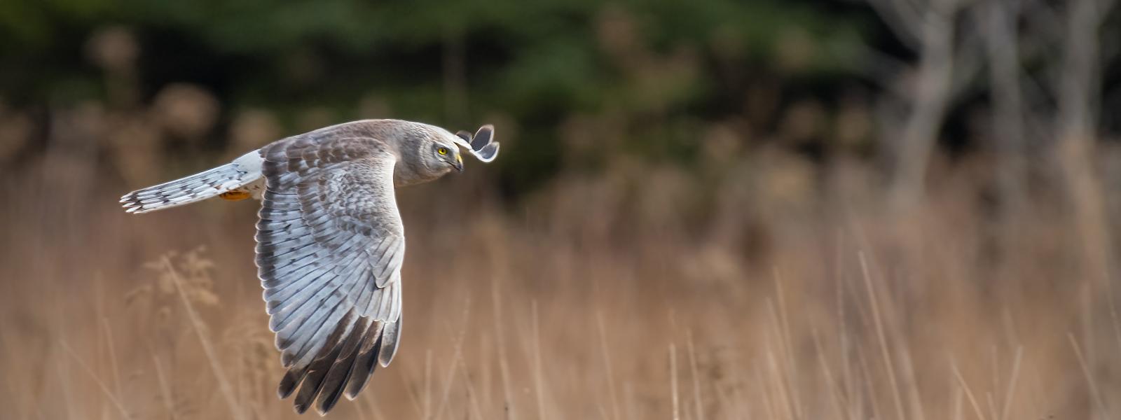
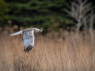
Dead trees within the water at the northern end of the lake provide nesting and roosting sites for several birds species including the osprey and tree swallow. The osprey's large nests are made of twigs and lined with bark, moss, and grasses and can be used year after year. Look for these birds as they hover over the water in search of fish and dive feet first to grab their prey. The tree swallows use holes in these dead trees for their nests made of grasses and lined with feathers. Watch for these birds as they feed on insects caught in flight.
Both ospreys and tree swallows will build nests in man-made structures such as platforms or nest boxes if natural nest sites are not available. Look for the osprey nest platforms, nearby purple martin houses and duck boxes.
Directions to next stop:
- Turn right out of parking lot to continue on Cranberry Road. Drive approximately 2.2 miles (paved portion of road begins after ½ mile)
- At stop sign, turn right onto Jersey Hollow Road and drive 3.2 miles
- Turn left onto Maple Summit Road and drive 4 miles
- Turn left onto Route 381 South
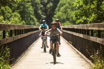
- Drive 1.8 miles and turn right into parking area at Ferncliff and walk 5 minutes along Great Allegheny Passage to the high bridge
Stop 9 - Ohiopyle State Park - Ferncliff High Bridge
From the Ferncliff Parking lot at the trailhead sign, head to the right on the Great Allegheny Passage trail and walk 5 minutes along the trail for a bird's eye view of the Youghiogheny River Gorge.
Ohiopyle State Park encompasses 20,500 acres including mature forests and 14 miles of the pristine Youghiogheny River flowing through the heart of the park. It is a natural history gem, perfect for birders and plant enthusiasts alike.
As you step onto the High Bridge you enter the world of wood warblers. These tiny songbirds travel from winter grounds in the tropics to the forests of North America. They follow the emergence of hatching insects along their path, as tiny caterpillars awake from hibernation the birds migrate northward. Male warblers are brightly colored to attract females while their mate's feathers are green and yellow, designed to blend with their forest canopy home. Many warblers spend most of their time feeding in the canopy. On the high bridge you have the perfect opportunity to see them in this unique setting. Look for northern parula, yellow-rumped warbler, yellow-breasted chat and cerulean warblers.
Not to be missed is a trip to the high bridge in late May. The tulip poplar trees, a member of the magnolia family, are in bloom. This spectacle is hard to view from the ground but from here this spectacular display is at eye level.
 Directions to next stop:
- Turn left out of parking area and return to intersection with Route 381
- Turn left onto Route 381 North
- Drive approximately 10.4 miles to Normalville and turn right to continue north on Route 381/711
- Drive approximately 9.5 miles and turn left at blinking light onto Route 711/31 West
- Drive approximately 2 miles to return to Donegal
We hope you enjoyed your tour through the Laurel Highlands. This scenic driving tour is part of the Laurel Highlands Conservation Landscape Initiative.